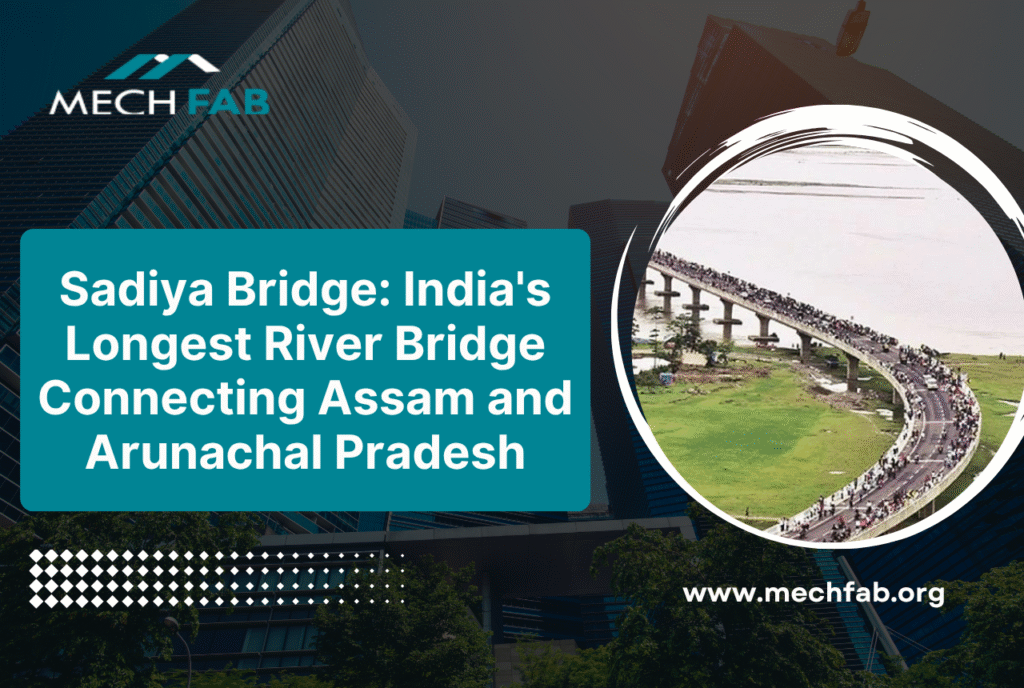
Imagine a structure so grand that it stretches across one of the world’s mightiest rivers, cutting travel time by five hours and connecting two states with a single, seamless ribbon of concrete and steel. This is the story of the Sadiya Bridge, officially known as the Bhupen Hazarika Setu, a testament to India’s engineering prowess and commitment to infrastructure development in the Northeast.
At 9.15 kilometres in length, the Dhola Sadiya Bridge stands as India’s second-longest bridge over water and the longest river bridge, connecting the villages of Dhola in Assam with Sadiya, providing crucial access to Arunachal Pradesh. Whether you’re a traveller planning to explore Northeast India, an engineering enthusiast, or someone curious about India’s infrastructure achievements, this comprehensive guide will take you through everything you need to know about this architectural marvel.
In this article, we’ll explore the history behind the Assam Sadiya Bridge, its strategic importance, engineering specifications, and why it has become a symbol of progress for the entire region. Let’s dive into the fascinating world of one of India’s most impressive infrastructure projects.
What is the Sadiya Bridge?
The Sadiya Bridge, more commonly referred to by locals as the Dhola Sadiya Bridge, is a beam bridge that creates the first permanent road connection between northern Assam and eastern Arunachal Pradesh. The bridge spans the Lohit River, a major tributary of the Brahmaputra, and was named after Bhupen Hazarika, a renowned artist and filmmaker from Assam.
Before this bridge was constructed, traveling between Assam and Arunachal Pradesh required a lengthy detour that consumed precious hours and limited economic opportunities for the region. The completion of this infrastructure project has transformed connectivity, reduced transportation costs, and opened new possibilities for trade and tourism in India’s Northeast.
Key Specifications:
- Total Length: 9.15 kilometers (5.69 miles)
- River Crossed: Lohit River (Brahmaputra tributary)
- States Connected: Assam and Arunachal Pradesh
- Total Project Length: 28.50 km (including approach roads)
- Bridge Type: Beam bridge
- Load Capacity: Designed to handle 60-tonne main battle tanks
The Dhola Sadiya Bridge photo opportunities are stunning, especially during sunrise and sunset when the structure appears to float above the mighty waters of the Lohit River, creating a breathtaking visual experience for visitors.
Which is the Longest River Bridge in India?
When people ask “which is the longest river bridge in India,” the answer depends on the specific category. The Dhola Sadiya Bridge, at 9.15 km in length, is currently the second longest bridge in India over water overall, but remains the longest river bridge specifically. It’s important to distinguish between different types of bridges:
Understanding Bridge Categories:
- Longest Bridge Over Water (Overall): The Atal Setu (Mumbai Trans Harbour Link) holds the title at 21.8 km, inaugurated in January 2024
- Longest River Bridge: Dhola Sadiya Bridge (Bhupen Hazarika Setu) at 9.15 km
- Longest Rail-Cum-Road Bridge: Bogibeel Bridge at 4.94 km
The distinction matters because the Assam Sadiya Bridge specifically crosses a river system (the Lohit-Brahmaputra), making it India’s longest river bridge even if other structures span greater distances over sea links or other water bodies.
The History and Development of Dhola Sadiya Bridge
Planning and Approval
The Ministry of Road Transport and Highways began feasibility studies for the project in August 2003, with construction approval granted in January 2009. The project was conceptualized as part of India’s infrastructure push in the Northeast, addressing both civilian connectivity and strategic defense requirements.
Construction Timeline
Construction commenced in November 2011 as a public-private partnership with Navayuga Engineering, initially targeting completion in 2015. However, like many ambitious infrastructure projects, the bridge faced challenges including:
- Complex river engineering requirements
- Seismic considerations in an earthquake-prone zone
- Logistical challenges of remote location
- Weather-related construction delays
Due to construction delays and cost overruns, the completion date was pushed to 2017, with the project ultimately costing around ₹10 billion (equivalent to ₹14 billion or US$166 million in 2023). Construction took over five years to complete.
Inauguration
The bridge was inaugurated on 26 May 2017 by Indian Prime Minister Narendra Modi in the presence of Nitin Gadkari, the Minister of Road Transport and Highways. The inauguration was a significant moment for the Northeast, symbolizing the government’s commitment to developing infrastructure in the region.
Dhola Sadiya Bridge: Engineering Excellence
The engineering behind the longest river bridge in India is nothing short of remarkable. Several factors make this structure a technical marvel:
Strategic Design Features
Military-Grade Construction: The bridge has been designed to handle the weight of 60-tonne (130,000-pound) main battle tanks such as the Indian Army’s Arjun and T-72 tanks. This specification reflects the bridge’s dual purpose as both civilian infrastructure and strategic military asset.
Seismic Resilience: Located in a seismically active zone, the bridge incorporates advanced engineering to withstand earthquakes and ensure long-term structural integrity.
River Engineering: Spanning the Lohit River, a powerful tributary of the Brahmaputra, required sophisticated hydrological studies and foundation engineering to account for monsoon flooding, river dynamics, and sediment flow.
Approach Roads: The total project length of 28.50 km includes carefully engineered approach roads that facilitate smooth traffic flow and provide additional connectivity to nearby areas.
Strategic Importance: Dhola Sadiya Bridge in Which River Basin
Understanding the Dhola Sadiya bridge in which river context is crucial to appreciating its strategic value. The bridge is built over the Lohit River, a major tributary of the Brahmaputra River, placing it in one of India’s most strategically sensitive regions.
Defense and Security
Located close to the India-China border, the bridge facilitates rapid movement of Indian Armed Forces to the border state of Arunachal Pradesh, making it an important tactical asset in the ongoing territorial dispute as China has contested India’s claim to the region.
The bridge enables:
- Faster deployment of military personnel and equipment
- Improved logistics for border security forces
- Enhanced surveillance and patrol capabilities
- Better emergency response infrastructure
Economic Connectivity
Beyond military applications, the Assam Sadiya Bridge serves critical economic functions:
Reduced Travel Time: The bridge cuts travel time between Assam and Arunachal Pradesh by approximately five hours and reduces the distance by 165 kilometers.
Trade Facilitation: Improved connectivity enables better market access for agricultural products, handicrafts, and other goods from Arunachal Pradesh.
Tourism Development: Easier access has opened Northeast India to tourism, benefiting local economies and promoting cultural exchange.
Regional Integration: The bridge strengthens the economic integration of India’s Northeast, often referred to as the “Seven Sisters” states.
Visiting the Sadiya Bridge: A Tourist Perspective
The Dhola Sadiya Bridge has become more than just infrastructure, it’s a tourist attraction drawing visitors from across India and beyond. Here’s what you need to know if you’re planning a visit:
Best Time to Visit
October to March: The winter and early spring months offer the most pleasant weather with clear skies, perfect for photography and sightseeing.
Monsoon Season (June-September): While beautiful, the monsoon brings heavy rainfall that can affect travel plans. However, witnessing the swollen Brahmaputra beneath the bridge is a spectacular sight.
What to Expect
Scenic Beauty: The bridge offers panoramic views of the Lohit River, lush tea gardens of Upper Assam, and the distant hills of Arunachal Pradesh.
Photography Opportunities: The Dhola Sadiya bridge photo opportunities are exceptional, particularly during golden hour. The structure’s impressive length creates dramatic perspectives for landscape and architectural photography.
Local Culture: The journey to and from the bridge takes you through Assam’s tea-growing region and exposes you to the rich cultural heritage of the Northeast.
Nearby Attractions
When visiting the Sadiya Bridge, consider exploring:
- Dibru Saikhowa National Park: Known for its biodiversity and wild horses
- Roing and Dibang Valley: Scenic towns in Arunachal Pradesh
- Tea Gardens: Upper Assam’s verdant tea estates
- Tilinga Mandir Temple: Historic religious site in the region
The Economic Impact of the Longest River Bridge in India
The completion of the Assam Sadiya Bridge has had profound economic implications for the Northeast region:
Agriculture and Trade
The bridge has transformed agricultural economics by:
- Reducing transportation time for perishable goods
- Opening new markets for farmers in Arunachal Pradesh
- Decreasing transportation costs, improving profit margins
- Enabling year-round market access previously limited during monsoons
Industrial Development
Improved connectivity has attracted:
- Manufacturing investments in the region
- Infrastructure development projects
- Service sector growth, particularly tourism and hospitality
- Small and medium enterprise expansion
Employment Generation
The bridge project created:
- Direct construction employment for local workers
- Indirect jobs in supporting industries
- Ongoing maintenance and operation positions
- Tourism-related employment opportunities
Future Infrastructure Projects in the Region
The success of the Dhola Sadiya Bridge has paved the way for additional infrastructure investments in Northeast India:
The under-construction 19.28 km Dhubri-Phulbari bridge across the Brahmaputra River, connecting Meghalaya with Assam, is expected to become India’s longest river bridge, with completion slated for September 2028. This six-lane structure will further enhance regional connectivity.
Other upcoming projects include:
- Expansion of road networks connecting remote Arunachal areas
- Railway connectivity improvements
- Additional bridges across Brahmaputra tributaries
- Upgradation of existing infrastructure
Environmental Considerations
Large infrastructure projects like the Sadiya Bridge require careful environmental management:
River Ecology: Engineers implemented measures to minimize disruption to the Lohit River’s ecosystem, including careful construction timing to avoid spawning seasons for local fish species.
Wildlife Corridors: The bridge design considered wildlife movement patterns, particularly for elephants and other large mammals common in the region.
Sustainable Practices: Modern construction techniques minimized environmental footprint while ensuring structural longevity.
Cultural Significance: Honoring Bhupen Hazarika
The bridge was named after Bhupen Hazarika, an artist and filmmaker from Assam, acknowledging his cultural contributions to the region. Hazarika, often called the “Bard of Brahmaputra,” was a multifaceted personality who used art to bridge cultural divides, making him an apt namesake for a structure that literally bridges geographical barriers.
His legacy includes:
- Iconic songs celebrating Assamese culture and the Brahmaputra
- Films highlighting Northeast India’s social issues
- Contributions to Indian classical and folk music
- Advocacy for regional identity and pride
Naming the bridge after him ensures that every journey across this engineering marvel also honors the cultural richness of Northeast India.
Technical Innovations in Construction
The construction of the longest river bridge in India involved several technical innovations:
Foundation Engineering: Deep pile foundations were used to anchor the bridge in the river’s challenging sedimentary geology.
Precast Segments: Large portions of the bridge were constructed using precast concrete segments, ensuring quality control and faster construction.
Weather-Resistant Materials: Special concrete mixes and protective coatings were used to withstand the region’s high humidity and monsoon conditions.
Construction Equipment: Specialized equipment was deployed to work in the river environment, including floating cranes and underwater construction technology.
Maintenance and Longevity
Ensuring the Dhola Sadiya Bridge remains functional for decades requires comprehensive maintenance:
Regular Inspections: Engineers conduct routine inspections to identify wear, corrosion, or structural issues.
Preventive Maintenance: Scheduled maintenance activities prevent small issues from becoming major problems.
Monitoring Systems: Modern sensors monitor structural health, load distribution, and environmental factors affecting the bridge.
Emergency Protocols: Systems are in place for rapid response to any structural concerns or damage.
Impact on Real Estate and Development
The Assam Sadiya Bridge has catalyzed real estate and urban development in previously isolated areas:
Property Values: Land values along the bridge corridor have increased significantly.
Urban Planning: New township developments are being planned to capitalize on improved connectivity.
Commercial Development: Businesses are establishing operations near the bridge to serve travelers and facilitate trade.
Infrastructure Supporting Growth: Hotels, restaurants, fuel stations, and other services have emerged along the route.
Challenges Overcome During Construction
Building the longest river bridge in India involved overcoming significant obstacles:
Geographical Challenges:
- Working in a remote location with limited infrastructure
- Managing construction during monsoon seasons
- Transporting heavy materials to the construction site
Engineering Challenges:
- Managing river hydrology and flood conditions
- Ensuring seismic resilience
- Coordinating complex construction sequencing
Project Management:
- Coordinating between government agencies and private contractors
- Managing cost escalations and budget constraints
- Meeting quality standards while addressing delays
Lessons for Future Infrastructure Projects
The Dhola Sadiya Bridge experience offers valuable insights for future projects:
Public-Private Partnerships: The collaboration model demonstrated both benefits and challenges of PPP infrastructure development.
Planning Buffers: The importance of realistic timelines that account for geographical and logistical challenges.
Community Engagement: Involving local communities ensures smoother project execution and greater acceptance.
Environmental Integration: Balancing development needs with environmental protection from project inception.
Conclusion: A Bridge to the Future
The Sadiya Bridge stands as more than just concrete and steel spanning a river. It represents India’s commitment to developing its remote regions, ensuring national security, and creating economic opportunities for communities long isolated by geography. As the longest river bridge in India, the Dhola Sadiya Bridge symbolizes the possibilities that emerge when visionary planning meets engineering excellence.
Whether you refer to it as the Sadiya Bridge, the Dhola Sadiya Bridge, or the Bhupen Hazarika Setu, this engineering marvel has fundamentally transformed Northeast India. It has cut travel times, boosted regional economies, enhanced security infrastructure, and opened new horizons for millions of people.
For travelers, the bridge offers a scenic journey across one of India’s mightiest rivers. For engineers, it showcases what’s possible with modern construction techniques. For the people of Assam and Arunachal Pradesh, it represents connection, opportunity, and progress.
As you plan your next visit to Northeast India, make sure the Assam Sadiya Bridge is on your itinerary. Stand on this magnificent structure, gaze at the Lohit River flowing beneath you, and appreciate not just the engineering achievement, but the human aspiration it represents—to connect, to progress, and to build a better future together.